菲律宾Inquirer报(2018.2.6)中共基本完成在南海填岛军事化
转自:http://www.inquirer.net/specials/exclusive-china-militarization-south-china-sea
EXCLUSIVE: New photos show China is nearly done with its militarization of South China Sea
Aerial photographs obtained by Inquirer.net from a source show that China is almost finished transforming seven reefs claimed by the Philippines in the Spratly archipelago into island fortresses, in a bid to dominate the heavily disputed South China Sea.
Most of the photos, taken between June and December 2017, were snapped from an altitude of 1,500 meters and they showed the reefs that had been transformed into artificial islands in the final stages of development as air and naval bases.
Shown the photographs, Eugenio Bito-onon Jr., the former mayor of Kalayaan town on Pag-asa Island, the largest Philippine-occupied island in the Spratlys and internationally known as Thitu Island, recognized new facilities on the man-made isles.
‘Photos are authentic’
Bito-onon saw the construction going on when he flew over the islands with foreign journalists nearly two years ago.
“These photos are authentic. I flew with HBO before the elections in 2016. We got repeated warnings from the Chinese because we were circling over the islands. I see there are now additional vertical features,” Bito-onon said.
With its construction unrestrained, China will soon have military bastions on Kagitingan Reef, known internationally as Fiery Cross Reef; Calderon (Cuarteron), Burgos (Gaven), Mabini (Johnson South), Panganiban (Mischief), Zamora (Subi) and McKennan (Hughes) reefs from which to project its power throughout the region.
Within Philippines’ EEZ
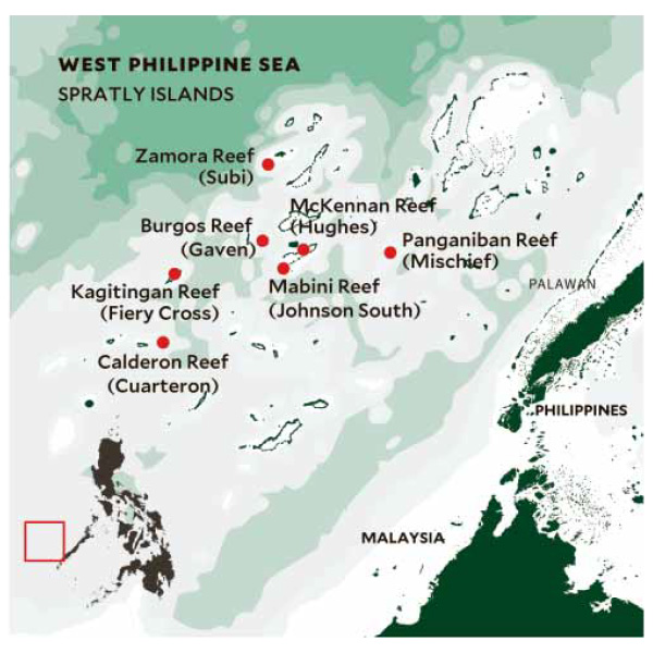
One of the reefs, Panganiban, lies within the Philippines’ 370-kilometer exclusive economic zone (EEZ) in the South China Sea. The UN-backed Permanent Court of Arbitration in The Hague has ruled that Panganiban Reef belongs to the Philippines.
In a report on China’s militarization of the South China Sea last December, US think tank Asia Maritime Transparency Initiative (Amti) said Kagitingan Reef had the most construction in 2017, with work spanning 110,000 square meters.
The runways for the three biggest reefs—Kagitingan, Panganiban and Zamora—appeared either completed or almost ready for use.
Lighthouses, radomes, communication facilities, hangars and multistory buildings had also been built on the artificial islands.
Amti, which described 2017 as a “constructive year for Chinese base building” in the South China Sea, noted the presence of underground tunnels, missile shelters, radars and high-frequency antennas on the artificial islands.
The photos obtained by Inquirer.net showed the consistent presence of cargo vessels believed to be used in transporting construction supplies to the artificial islands.
Military ships
Three military ships capable of transporting troops and weapons were docked at Panganiban Reef in a picture taken last Dec. 30. These were two transport ships (Hull Nos. 830 and 831) and an amphibious transport dock (989).
The Luoyang (527), a Type 053H3 Jiangwei II class missile frigate, was spotted about a kilometer from Zamora Reef last Nov. 15. This type of war vessel has two quadruple launchers installed amidships. It also has a Type 79A dual-barrel 100 mm gun installed on the bow deck, capable of firing 15-kilogram shells at a rate of 18 rounds per minute over a range of 22 km.
Last June 16, the Luzhou (592), a Type 056 Jiangdao class missile frigate, was photographed at Panganiban Reef. China’s defense ministry reported the vessel took part in live-fire exercises in the South China Sea last December.
On the smaller reefs—Burgos, Calderon, McKennan and Mabini—the photos showed helipads, wind turbines, observation towers, radomes and communication towers had been built.
A photo taken last Nov. 28 showed a single-barrel 100 mm gun had been positioned on McKennan Reef.
Status quo deal ignored
The extent of development on the reefs show that China has gone ahead with building military outposts in the Spratlys despite a 2002 agreement with
the 10-member Association of Southeast Asian Nations (Asean) not to change any features in the sea.
At the same time, China has softened the impact of its military buildup with pledges of investments to the Philippines and talk of a framework for negotiating with Asean a code of conduct for the management of rival claims in the strategic waterway.
Besides the Philippines and China, Brunei, Malaysia and Vietnam also claim parts of the Spratly archipelago. Taiwan is a sixth claimant.
North Korea’s missile and atomic weapon tests also helped draw international attention away from China’s construction activities on the reefs, although recent pronouncements from Malacañang indicated the Philippines was not exactly unaware of the Chinese military buildup in the Spratlys.
Roque: No longer news
Presidential spokesperson Harry Roque told a news briefing early last month that China’s militarization in the South China Sea was no longer news but the Philippines would not protest as long as China kept its “good faith commitment” that it would not reclaim any more islands in the waterway.
“The fact that they are actually using it now as military bases, as far as I’m concerned, is not new. It’s not news because we’ve always been against militarization of the area. But the good faith commitment is not to reclaim new islands. I hope that’s very clear,” Roque said.
“[T]he point is, has there been a breach of Chinese commitment not to reclaim any new islands or shoal in the area? For as long as there is none, then we continue to respect that they are true to their commitment not to do so. But I think, from the very beginning, China, we knew, was militarizing the area by reclaiming these areas and by using them as military bases,” he added.
Don’t trust a thief
Supreme Court Senior Associate Justice Antonio Carpio, a member of the legal team that argued the Philippine case against China’s claim to almost the entire South China Sea in the Hague arbitral court, slammed Roque’s position, comparing it to trusting a thief.
“You don’t rely on the good faith of the thief [who’s trying to break] into your house. If you have that mindset, you rely on the good faith of someone who’s trying to break into your house, that means you’re out [of touch] with reality. You’re in a fantasyland. That’s not how the world is put together. That’s not realpolitik,” Carpio said.
The Philippines is battling communist rebels, terrorists loyal to the Islamic State jihadi group, and Abu Sayyaf bandits but the country is facing a much bigger security threat, Carpio said.
“The biggest [security] problem is China. If we lose [our maritime space in the West Philippine Sea], we lose it forever,” Carpio told the Inquirer in a recent interview, using the local name of the waters within the Philippines’ EEZ in the South China Sea.
“And the area we will lose is huge, as big as the land area of the Philippines, about 300,000 square kilometers,” Carpio said.
China will never return the territory it grabs, he added. “We cannot go to the [International Court of Justice] because China has to agree and China will never agree to submit to arbitration.”
Arbitral ruling
China has ignored the Hague tribunal’s July 2016 ruling that invalidated Beijing’s sweeping claim to the South China Sea and declared it violated Manila’s sovereign right to fish and explore for resources in its own EEZ.
But President Duterte, who came to power two weeks before the ruling came down, has refused to assert the Philippine victory, wooing China instead for loans and investments.
China has been only too glad to be neighborly to the Philippines but it has also been determined to finish its island fortresses in the South China Sea and present its rivals for territory in the waterway with a fait accompli when they sit down to negotiate the code of conduct.
Security analyst Jose Antonio Custodio questions Malacañang’s playing down China’s militarization of the South China Sea in exchange for economic assistance.
“We are talking [about] trillions of dollars [in] natural resources and we are compromising our territorial claims. At the end of the day, these are not Chinese grants but loans so you don’t have to be a rocket scientist to see the disadvantageous position the Philippines is putting itself into,” Custodio said.
Jay Batongbacal, director of the University of the Philippines Institute for Maritime Affairs and Law of the Sea, said the time when the Philippines should have protested China’s militarization had long passed. But the situation worsened when the country refused to bring up the arbitration ruling at the Asean Summit in Manila last year.
“That helped China in doing everything that needs to be completed. If ever the government one day realizes that those military aircraft are based there, definitely it has no one to blame but itself, because it did not act when the time to act was right,” Batongbacal said.
Claimants disunited
Asean’s silence on the arbitral ruling in favor of the Philippines during the Manila summit was a diplomatic score for China.
“Unity among the claimants is one of China’s biggest fears,” Batongbacal said.
“[The Chinese] see it as a huge threat when the surrounding countries are aligned. That’s what they don’t like the most because they think it’s containment. The fact that Asean didn’t come to unite about the disputes because we did not push through putting it on the table, all of that really favored China. They had a big win and that’s a huge relief for them,” he added.
Carpio said the Philippines could have generated support from the international community if it asserted its victory over China in the arbitration case.
“If we are not aggressive, if we are sitting on the ruling and we are not enforcing it, the others will not support us,” he said.
The military, for its part, cannot do anything but follow the government’s foreign policy.
“We still navigate in those waters. But we are instruments of national policy so we just follow whatever our national leaders and policymakers decide,” said a ranking military official who requested anonymity.
“Were there challenges [from China]? Yes, but we also challenged them, that’s part of the rules of the road. But the policies of the government are not only military, there’s also political, economic and diplomatic. You can’t confine it to the military,” the official said.
What’s at stake
If the Philippines does not assert its legal victory, it stands to lose 80 percent of its EEZ in the South China Sea, covering 381,000 square kilometers of maritime space, including the entire Recto Bank, or Reed Bank, and part of the Malampaya gas field off Palawan, as well as all of the fishery, oil and gas and mineral resources there, Carpio said.
“My estimate is 40 percent of water in the Philippines is in the West Philippine Sea, so that’s 40 percent of the fish that we can catch and we will lose that as a food source,” he said.
“Malampaya supplies 40 percent of the energy requirement of Luzon. If Malampaya runs out of gas in 10 years or less . . . we will have 10 to 12 hours of daily brownouts in Luzon. It will devastate the economy,” he added.
附:中国南海军事工程详尽细节首次曝光
纽约时报,MEGAN SPECIA, MIKKO TAKKUNEN,
《菲律宾每日问询者报》 (The Philippine Daily Inquirer)从未具名来源获取的这些照片,提供了迄今为止有关其建筑规模和军事开发本质最清晰的视角。
五角大楼和菲律宾军方均拒绝就此发表评论。《纽约时报》无法独立核实这些图片。公布的注释显示它们摄于2016年6月至2017年12月期间。
但监测南海发展动向的专家说,照片拍摄的是有争议的岛屿,与他们多年来一直在监测的发展动态卫星图片相符。
华盛顿国际战略研究中心 亚洲海事透明度倡议 (Asia Maritime Transparency Initiative at the Center for Strategic and International Studies)助理研究员康纳·克罗宁(Conor Cronin)说,新公布的照片中建筑的规模和他所在团队定期评估的该地区照片中的建筑一样。该倡议对一个长期迷雾笼罩的地区的发展动向进行着监测。
他说,这些照片的惊人之处在于,外界首次得以看到重要的表面细节。
“这是罕见的能公开看到的照片,”克罗宁说,并指出这些从比卫星近得多的角度拍摄到的细节照片具有丰富的洞察力。“这再次表明这些设施多么完善和它们将具备的能力。”
斯普拉特利群岛的发展动向 引起了邻国的愤怒 。它们也对南海的这部分海域提出了主权主张。菲律宾、台湾、越南和马来西亚均不同程度地声称拥有该地区的部分海域。
尽管随着中国与其他国家就该地区的行为准则协议进行谈判(该协议似乎是在不解决根本的主权争端的情况下进行经济开发),令紧张局势有所缓和,但保持不减的修建步伐可能会引发新的紧张局势。
国际战略研究中心的亚洲事务高级顾问葛来仪(Bonnie S. Glaser)称,这些照片提供了一个独特的视角。她说她认为,尤其是考虑到照片上的注释,它们极有可能是军用飞机拍摄的。
“真正令人相当震惊的是,在这些航拍照片中可以多么清楚地看到已经修建了多少设施,”葛来仪说。“真的是近距离、事无巨细的。”
亚洲海事透明度倡议最近的一项评估显示,仅在2017年,中国在南海开发的地上和地下面积就高达 72英亩 (约合0.3平方公里)。自2013年开工以来,中国在该地区的开发面积超过3200英亩(约合12.9平方公里)。
最近,中国把注意力从疏浚和填海造地转移到了建设飞机跑道、雷达和通信设施及机库上。
在曾经大部分在水下的美济礁(Mischief Reef)上,中国已经开发出了1379英亩(约合5.6平方公里)的土地。据称,该岛的最新照片上显示有一条近两英里(约合3.2公里)长的跑道和混凝土建筑。分析人士说,中国军用飞机开始在那里着陆只是时间问题。
“他们会开始从这些跑道上起飞执行任务,而且我相信,他们还会开始真的把飞机停放在这些经过加固的掩体里,至少是短期停放,”葛来仪说。“他们修建它们就是为了这个目的。”
中国国防部周三 宣布 将在南海进行战斗机训练演习,但并没有说明是否有飞机飞往相关岛屿。
美济礁在菲律宾叫庞阿尼班礁(Panganiban),距离菲律宾海岸 约140英里 (约合225公里)。 海牙的一个国际法庭 裁定它属于菲律宾领海。
亚洲海事透明度倡议在最近对该岛的 评估 中表示,美济礁上的建筑占地17英亩(约合6.9万平方米)。
“包括用于存放弹药和其他物资的地下储存空间,已竣工的机库和导弹掩体,以及新的雷达和通信阵列,”该组织写道。
航拍照片中的类似细节也指向了同样的结论。
尽管与由10个国家组成的东南亚国家联盟(Association of South East Asian Nations)就南海开发行为准则进行的谈判陷入了停滞,但中国的开发仍在继续。
“它们要花很长时间才能达成协议,但中国没有放慢扩大这些基地的速度,”克罗宁说。“他们仍在迅速行动。”


文章版权归原作者所有。
